
Written by Haskell Moore
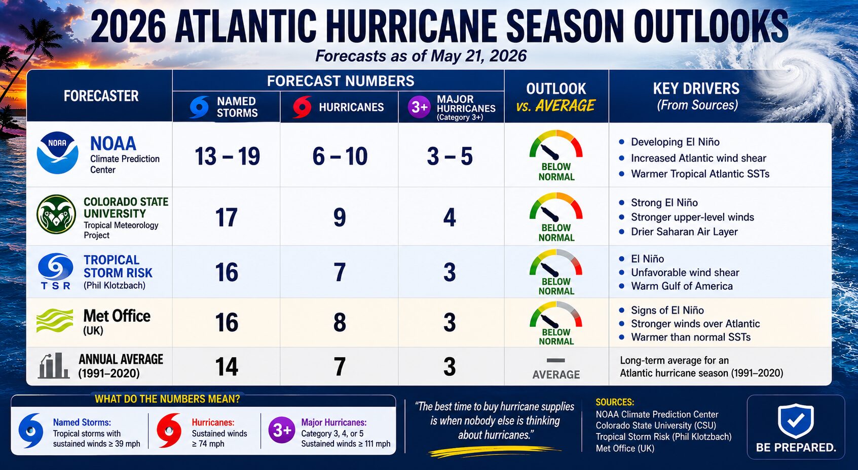
The much-awaited National Oceanic and Atmospheric Administration (NOAA) 2026 Atlantic Hurricane Season Outlook was published on Thursday, May 21, and NOAA is predicting a 55% chance of a below-normal season.
One of the primary reasons for the prediction of a below-normal season is the anticipated onset of El Niño conditions within the ENSO cycle. What is ENSO? The El Niño-Southern Oscillation, commonly called ENSO, is a naturally occurring climate cycle involving changing ocean temperatures and atmospheric conditions across the equatorial Pacific Ocean. ENSO has three phases: El Niño, La Niña, and neutral conditions.
During El Niño, warmer Pacific waters tend to increase upper-level winds over the Atlantic Basin. This creates stronger wind shear, which can disrupt hurricane formation and often leads to quieter Atlantic hurricane seasons. La Niña typically produces the opposite effect by reducing wind shear and creating conditions more favorable for tropical storm and hurricane development. Neutral conditions generally fall somewhere in between and can be less predictable. Although ENSO is only one of many factors affecting hurricane activity, it is one of the most closely monitored seasonal indicators.
So what does this prediction mean for families living in hurricane-prone regions? Those of us in the disaster preparedness world, including former FEMA Administrator W. Craig Fugate, often ask the same question: “So what? What are you going to do differently?”
It is important to remember that these predictions are highly valuable to industry professionals such as energy companies, insurance providers, and emergency management agencies. However, at the individual level, the forecast numbers themselves are often far less important. Let me give you a couple of examples that illustrate why I don’t place too much emphasis on preseason hurricane predictions alone.
NOAA’s predictions for the 2010 Atlantic hurricane season were considered particularly ominous, forecasting 14 to 23 named storms, 8 to 14 hurricanes, and 3 to 7 major hurricanes. To help estimate what an upcoming season may look like, forecasters often compare current atmospheric and ocean conditions to past hurricane seasons with similar patterns. These past comparison seasons are referred to as “analog years.”
One of the closest analog years to 2010 was 2005, the season that brought Hurricanes Katrina, Rita, and Wilma to the United States. And indeed, 2010 turned out to be an extremely active season, producing 19 named storms, 12 hurricanes, and 5 major hurricanes. Remarkably, however, not a single hurricane made landfall in the continental United States during the 2010 season.
Although 2010 was an extremely active hurricane season, large-scale steering currents largely kept storms away from the United States. Had those steering patterns shifted even modestly, the season could have had a dramatically different outcome.
My favorite example, which impacted my family directly, was Hurricane Alicia in 1983. That year was the least active Atlantic hurricane season since 1930, producing only four named storms. Yet despite the unusually quiet season, Alicia became a powerful and destructive hurricane for the Texas coast.
Alicia made landfall near Galveston on August 18, 1983, as a Category 3 hurricane with winds near 115 mph, bringing destructive winds, storm surge, widespread power outages, and severe damage across the upper Texas coast. Alicia caused approximately $2 to $3 billion in damage, became the costliest hurricane in U.S. history at that time, and resulted in 21 direct fatalities.
Another key point to remember about Alicia is that the Gulf can sometimes play by a different set of rules than the Atlantic’s Main Development Region. Unlike many hurricanes that strike the United States after forming in the tropical Atlantic, Alicia developed from a weakening frontal boundary over the Gulf, essentially an old cold front. That boundary helped provide the initial atmospheric disturbance needed for development. Combined with very warm Gulf waters and favorable upper-level atmospheric conditions, the system quickly organized and intensified into a major hurricane before making landfall along the upper Texas coast.
Because Alicia developed over the Gulf, there was very little time for families in the Houston-Galveston region to prepare. The first news report I remember seeing about Alicia was on Sunday, August 14, when forecasters began monitoring a disturbance in the Gulf. I still vividly remember putting on my jacket to leave for work on Monday when the local television meteorologist announced that Tropical Storm Alicia had formed. By Wednesday, Alicia had strengthened into a hurricane and was rapidly intensifying. Early Thursday morning, at approximately 2:00 a.m., Alicia made landfall near Galveston and barreled directly into Houston. For those who had not made their preparations earlier, they had only a day or two to obtain supplies and get ready for the storm.
For my family, Hurricane Alicia itself did not cause major damage to our home, but the subsequent power outage was quite brutal. We were without power for over a week during the middle of August in Houston. Back then, generators were not as quiet, efficient, and affordable as they are today. A friend of mine told me he had a man knock on his door with a trailer full of generators and sold him a medium-sized model for $1,500. Adjusted for inflation, that would be nearly $5,000 today!
Fortunately, there is now a wide selection of high-quality generators available at a fraction of the relative cost. Paired with a small portable air conditioner or a window unit, life can be much more tolerable during the power outages that often follow a hurricane. Even a modest 3,000-watt generator can power an inverter-style window air conditioner to keep a bedroom cool, a refrigerator to provide cold drinks, and a microwave oven to heat meals.
If you are interested in purchasing a generator at a substantial discount, you can use discount code PREPARE30 at checkout for 30% off generators, power stations, parts, and accessories at the FIRMAN Power Equipment website, or simply use this link:
https://firmanpowerequipment.com/collections/allow-coupons
The other issue we encountered during Alicia was insufficient lighting during the extended power outage. All I had were a couple of inexpensive flashlights and a few batteries. We eventually resorted to candles for much of the outage, which made inspecting storm damage, performing repairs, and simply navigating through a dark house much more difficult.
Today, there is a wide variety of high-quality lighting solutions available for sustained power outages. I have used MAGLITE flashlights around our home since 1999 and keep several at home and in my vehicles for emergencies. One of my favorites is the MAGLITE ML300L 4D LED “long running” flashlight. It can project a beam over 500 yards, making it ideal for checking your property, home, and even the all-important rooftop, for damage. The beam can be adjusted from a tight spotlight to a broad floodlight, and the 1,000-lumen output can be reduced to ECO mode for indoor nighttime use. In ECO mode, the flashlight can operate continuously for over two weeks on a single set of batteries.
For everyday use around the house or close-range outdoor lighting, I also like the XL50 pocket flashlight. It is compact, lightweight, produces 200 lumens of light, and like all MAGLITE flashlights, is rugged, water-resistant, and highly reliable. You can receive 10% off your entire order at MAGLITE.com by using discount code HURRICANE10 at checkout.
From my experience in teaching disaster preparedness for over 25 years, I believe the most important step in preparing for hurricane season is creating an action plan, a hurricane preparedness shopping list, and a grocery list. All three of these prioritized lists are covered in my previous Post article at the following link: https://thepostnewspaper.net/2025/05/31/hurricane-forecasts-and-your-family-why-planning-still-matters-most/
If your civic group, employer, agency, HOA, or other organization would like a free one-hour hurricane preparedness webinar, feel free to email me at HASKELL@HIDEFROMTHEWIND.COM. To date, more than 10,000 people have attended my live seminars, and another 14,000 have attended my webinars. This includes 873 attendees during my latest webinar for BP (formerly British Petroleum) in May 2026. These presentations make excellent lunch-and-learn sessions, and I strive to keep them light, entertaining, and highly informative.
There is also a wealth of hurricane preparedness information available on my website at https://www.hidefromthewind.com/. Be sure to visit the Recommended Products section to see many of the preparedness products I personally use and recommend and click on the Generators tab for additional information on backup power solutions.
If you would like to learn more about hurricane preparedness, check out my book, Hurricane Preparedness for the Home and Family, available on Amazon in both paperback and Kindle formats. All proceeds from the sale of this book are donated to the Louisiana Cajun Navy ( https://louisianacn.com/ ).
Full disclosure: I am a FIRMAN Power Equipment Gold Brand Affiliate and a MAGLITE Brand Ambassador. When you use my discount codes on either website, you receive a discount on your purchase, and I receive a commission that helps support my hurricane preparedness training.

